Description:
What's in the box
Legal Disclaimer
Missing box... Not sure of warranty status...
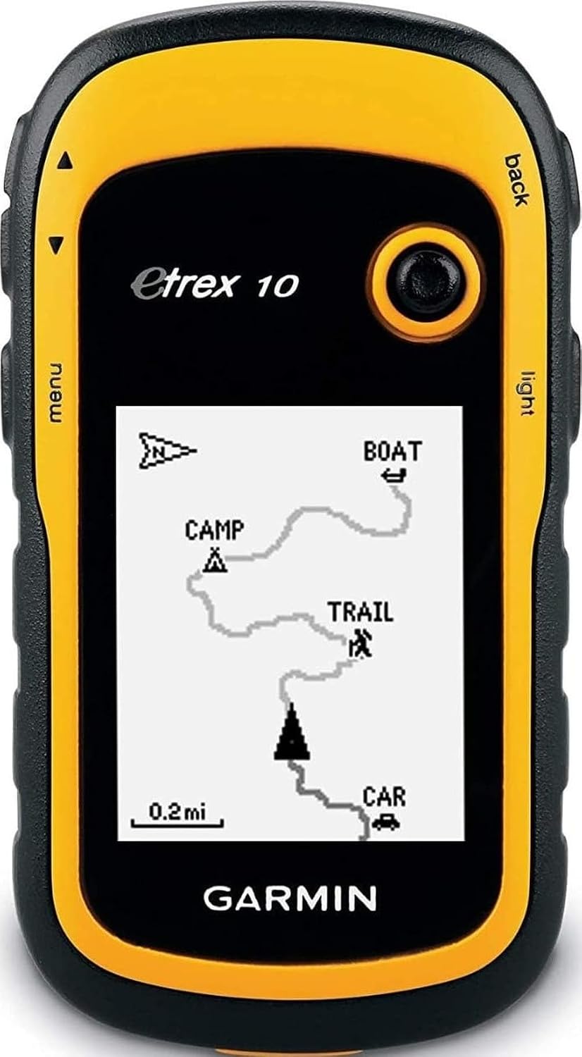
The eTrex 10 makes a great choice in handheld navigation for the budget savvy outdoor enthusiast. This eTrex model is equipped with a high-sensitivity GPS receiver, a 2.2-inch monochrome display, and a worldwide basemap making it easier than ever to see where you are and where you have been. Garmin Connect compatible (online community where you analyze, categorize and share data).
Details:
| Brand | Garmin |
|---|---|
| Model Name | eTrex 10 |
| Vehicle Service Type | Car, Truck, Motorcycle, etc. |
| Screen Size | 2.2 inches |
| Special Feature | Paperless Geocaching, Track More Satellites |
| Connectivity Technology | USB |
| Map Type | Australia |
| Included Components | eTrex 10, Lanyard, USB cable, Manual |
| Audio Output Mode | Digital |
| Battery Life | 20 hours |
Visit the Garmin Store
Garmin 010-00970-00 eTrex 10 Worldwide Handheld GPS Navigator
AED92514
Quantity:
Order today to get by 7-14 business days
This item qualifies for free delivery
 Imported From: United States
At BOLO, we work hard to ensure the products you receive are new, genuine, and sourced from reputable suppliers.
Every product in the BOLO catalogue is sourced through our Verified Global Supply Network of verified sellers, authorized distributors or directly from the manufacturer.
Each product undergoes thorough inspection and verification at our consolidation and fulfilment centers to ensure it meets our strict authenticity and quality standards before being shipped and delivered to you.
If you ever have concerns regarding the authenticity of a product purchased from us, please contact Bolo Support. We will review your inquiry promptly and, if necessary, provide documentation verifying authenticity or offer a suitable resolution.
Your trust is our top priority, and we are committed to maintaining transparency and integrity in every transaction.
While we strive to display accurate information, variations in packaging, labeling, instructions, or formulation may occasionally occur due to regional differences or supplier updates. For detailed or manufacturer-specific information, please contact the brand directly or reach out to BOLO Support for assistance.
Unless otherwise stated, all prices displayed on the product page include applicable taxes and import duties.
BOLO operates in accordance with the laws and regulations of United Arab Emirates. Any items found to be restricted or prohibited for sale within the United Arab Emirates will be cancelled prior to shipment. We take proactive measures to ensure that only products permitted for sale in United Arab Emirates are listed on our website.
All items are shipped by air, and any products classified as “Dangerous Goods (DG)” under IATA regulations will be removed from the order and cancelled.
All orders are processed manually, and we make every effort to process them promptly once confirmed. Products cancelled due to the above reasons will be permanently removed from listings across the website.

eTrex
Find Fun
eTrex supports geocaching GPX files for downloading geocaches and details straight to your unit. eTrex stores and displays key information, including location, terrain, difficulty, hints and descriptions, which means no more manually entering coordinates and paper printouts.
Keep Your Fix
With its high-sensitivity, WAAS-enabled GPS receiver and HotFix satellite prediction, eTrex locates your position quickly and precisely and maintains its GPS location even in heavy cover and deep canyons.
Go Global
The eTrex series is the first-ever consumer-grade receivers that can track both GPS and GLONASS satellites simultaneously. When using GLONASS satellites, a system developed by the Russian Federation, the time it takes for the receiver to 'lock on' to a position is (on average) approximately 20 percent faster than using GPS.
Plan Your Next Trip
- Take charge of your next adventure with BaseCamp, software that lets you view and organize maps, waypoints, routes, and tracks
- This free trip-planning software even allows you to create Garmin Adventures that you can share with friends, family or fellow explorers.
- BaseCamp displays topographic map data in 2-D or 3-D on your computer screen, including contour lines and elevation profiles. It also can transfer an unlimited amount of satellite images to your device when paired with a BirdsEye Satellite Imagery subscription.
Similar suggestions by Bolo
More from this brand
Similar items from “Handheld GPS Units”
Share with
Or share with link
https://www.bolo.ae/products/UO00542AI32
Visit the Garmin Store
Garmin 010-00970-00 eTrex 10 Worldwide Handheld GPS Navigator
AED92514
Quantity:
Order today to get by 7-14 business days
This item qualifies for free delivery
Imported From: United States
At BOLO, we work hard to ensure the products you receive are new, genuine, and sourced from reputable suppliers.
Every product in the BOLO catalogue is sourced through our Verified Global Supply Network of verified sellers, authorized distributors or directly from the manufacturer.
Each product undergoes thorough inspection and verification at our consolidation and fulfilment centers to ensure it meets our strict authenticity and quality standards before being shipped and delivered to you.
If you ever have concerns regarding the authenticity of a product purchased from us, please contact Bolo Support. We will review your inquiry promptly and, if necessary, provide documentation verifying authenticity or offer a suitable resolution.
Your trust is our top priority, and we are committed to maintaining transparency and integrity in every transaction.
While we strive to display accurate information, variations in packaging, labeling, instructions, or formulation may occasionally occur due to regional differences or supplier updates. For detailed or manufacturer-specific information, please contact the brand directly or reach out to BOLO Support for assistance.
Unless otherwise stated, all prices displayed on the product page include applicable taxes and import duties.
BOLO operates in accordance with the laws and regulations of United Arab Emirates. Any items found to be restricted or prohibited for sale within the United Arab Emirates will be cancelled prior to shipment. We take proactive measures to ensure that only products permitted for sale in United Arab Emirates are listed on our website.
All items are shipped by air, and any products classified as “Dangerous Goods (DG)” under IATA regulations will be removed from the order and cancelled.
All orders are processed manually, and we make every effort to process them promptly once confirmed. Products cancelled due to the above reasons will be permanently removed from listings across the website.
Description:
What's in the box
Legal Disclaimer
Missing box... Not sure of warranty status...
The eTrex 10 makes a great choice in handheld navigation for the budget savvy outdoor enthusiast. This eTrex model is equipped with a high-sensitivity GPS receiver, a 2.2-inch monochrome display, and a worldwide basemap making it easier than ever to see where you are and where you have been. Garmin Connect compatible (online community where you analyze, categorize and share data).
Details:
| Brand | Garmin |
|---|---|
| Model Name | eTrex 10 |
| Vehicle Service Type | Car, Truck, Motorcycle, etc. |
| Screen Size | 2.2 inches |
| Special Feature | Paperless Geocaching, Track More Satellites |
| Connectivity Technology | USB |
| Map Type | Australia |
| Included Components | eTrex 10, Lanyard, USB cable, Manual |
| Audio Output Mode | Digital |
| Battery Life | 20 hours |
eTrex
Find Fun
eTrex supports geocaching GPX files for downloading geocaches and details straight to your unit. eTrex stores and displays key information, including location, terrain, difficulty, hints and descriptions, which means no more manually entering coordinates and paper printouts.
Keep Your Fix
With its high-sensitivity, WAAS-enabled GPS receiver and HotFix satellite prediction, eTrex locates your position quickly and precisely and maintains its GPS location even in heavy cover and deep canyons.
Go Global
The eTrex series is the first-ever consumer-grade receivers that can track both GPS and GLONASS satellites simultaneously. When using GLONASS satellites, a system developed by the Russian Federation, the time it takes for the receiver to 'lock on' to a position is (on average) approximately 20 percent faster than using GPS.
Plan Your Next Trip
- Take charge of your next adventure with BaseCamp, software that lets you view and organize maps, waypoints, routes, and tracks
- This free trip-planning software even allows you to create Garmin Adventures that you can share with friends, family or fellow explorers.
- BaseCamp displays topographic map data in 2-D or 3-D on your computer screen, including contour lines and elevation profiles. It also can transfer an unlimited amount of satellite images to your device when paired with a BirdsEye Satellite Imagery subscription.
Similar suggestions by Bolo
More from this brand
Similar items from “Handheld GPS Units”
Share with
Or share with link
https://www.bolo.ae/products/UO00542AI32